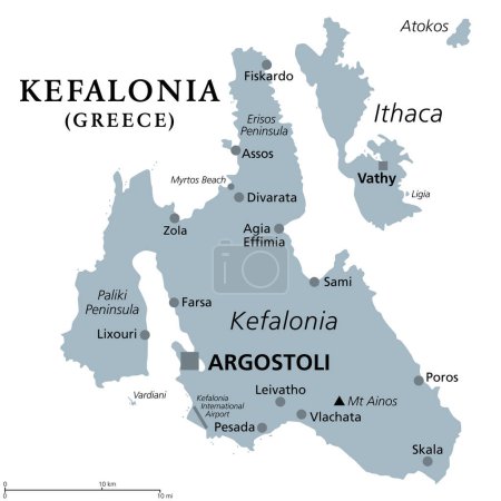
Diseño vibrante Felicia Amelloides para la dec ...

Diseño vibrante Felicia Amelloides para la decoración del hogar

Media-ID: B:788474132
Nutzungsrecht: Kommerzielle und redaktionelle Nutzung

Diseño vibrante Felicia Amelloides para la decoración del hogar

Vorschau      
  • Varianten

  • Mediainfos

Dieses Bild mit unserem Kundenkonto ab 0,95 € herunterladen!
Standardlizenz: EPS
Format Bildgröße Downloads  
Vektorgrafik eps 1
Standardlizenz: JPG
Format Bildgröße Netto Brutto Preis
Web S
0,5 MP
500x500 Pixel
16,93x16,93 cm (75 dpi)
3,90 € 4,17 €
Print M
2 MP
1000x1000 Pixel
8,47x8,47 cm (300 dpi)
6,90 € 7,38 €
Print XL
8 MP
2000x2000 Pixel
16,93x16,93 cm (300 dpi)
12,90 € 13,80 €
Print XXL
15 MP
5250x5250 Pixel
44,45x44,45 cm (300 dpi)
15,90 € 17,01 €
Standardlizenz: EPS
Format Bildgröße Netto Brutto Preis
Vektorgrafik eps 9,90 € 10,59 €
Merchandisinglizenz: EPS
Format Bildgröße Netto Brutto Preis
Vektorgrafik eps 79,90 € 85,49 €
Media-ID: B:788474132
Aufrufe: 1
   
Beschreibung: Diseño vibrante Felicia Amelloides para la decoración del hogar

Nutzungslizenz

Nutzungsrecht: Kommerzielle und redaktionelle Nutzung

Userinfos

Hinzugefügt von: Orxbyte
Weitere Medien von Orxbyte

Bewertung

Bewertung:
Bewertungen: 0 / Durchschnitt: 0

Ähnliche lizenzfreie Vektorgrafiken

Santorini, an island of Greece, political map. Officially Thira and classical Greek Thera, is an archipelago and remnant of a caldera in the Aegean Sea, and the southernmost member of the Cyclades.
Kefalonia, Greek island, gray political map. Also known as Cephalonia, Kefallinia or Kephallenia. The largest Ionian Island, located in western Greece and in the Ionian Sea, with capital Argostoli.
Liguria and the Italian Riviera, the Ligurian Riviera, political map. Region of north-western Italy, with capital Genoa. A narrow coastal strip between Ventimiglia and La Spezia, on the Ligurian Sea.
Samos, Greek island, political map. Island in the eastern Aegean Sea, and separated of the western Turkey coast by the Mycale Strait. Rich city-state in ancient times and the birthplace of Pythagoras.
Samos, Greek island, gray political map. Island in eastern Aegean Sea, and separated of western Turkey coast by the Mycale Strait. Rich city-state in ancient times and the birthplace of Pythagoras.
Liguria and the Italian Riviera, or Ligurian Riviera, gray political map. Region of north-western Italy, with capital Genoa. Narrow coastal strip between Ventimiglia and La Spezia on the Ligurian Sea.
Corfu, island of Greece, political map. Also known as Kerkyra, a Greek island in the Ionian Sea and part of the Ionian Islands. With Othonoi, Ereikoussa and Mathraki it forms the Corfu Regional Unit.
Elba, political map, Mediterranean island in Tuscany, Italy, with capital Portoferraio. Located in the Tyrrhenian Sea and largest island in the Tuscan Archipelago. Site of the first exile of Napoleon.
Paros, Greek island, gray political map. Island of Greece in the Aegean Sea, west of Naxos, and part of the Cyclades. With islands Antiparos, Despotiko and Stroggyli in the west. Illustration. Vector
Corsica, gray political map. French island in the Mediterranean Sea, north of Italian island Sardinia, with capital Ajaccio. One of the 18 regions of France and a territorial collectivity of France.
Lefkada, regional unit, gray political map. Part of Ionian Islands in Greece, also known as Lefkas, Leukas or Leucadia. With Tilevoides Islands Meganisi, Kalamos, Kastos, Skorpios and smaller islets.
Malta political map
Skiathos, small Greek island, political map. Island in the Aegean Sea, part of the Sporades, with the main town Skiathos, and with neighboring islets Tsoungria, Arkos and Aspronisi and smaller ones.
Free Republic of Liberland, gray political map. Unrecognized micronation in Southeast Europe, claiming Gornja Siga, uninhabited and disputed land on western bank of Danube between Croatia and Serbia.
Naxos and Lesser Cyclades, Greek islands, political map. Island group in the Aegean Sea, and part of the Cyclades archipelago. Popular tourist destination with a number of beaches and several ruins.
Corfu, island of Greece, gray political map. Also Kerkyra, is a Greek island in the Ionian Sea, and part of the Ionian Islands. With Othonoi, Ereikoussa and Mathraki it forms the Corfu Regional Unit.
Milos, island of Greece, political map. Volcanic Greek island in the Aegean Sea and part of the Cyclades. Together with Antimilos and smaller islets a municipality, neighboring Kimolos and Polyaigos.
Free Republic of Liberland, gray political map with Liberland Village near Apatin. Micronation in Europe claiming uninhabited parcel of land Gornja Siga on Danube, disputed between Croatia and Serbia.
Albania political map
Zakynthos, Greek island, gray political map. Also Zakinthos or Zante, a part of the Ionian Islands of Greece, and a separate regional unit, with the same named capital Zakynthos. Illustration. Vector.