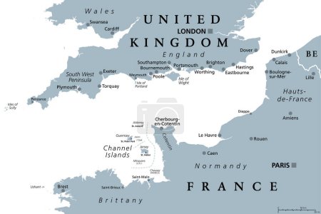
Canal de la Mancha, mapa político gris. Canal ... 

Media-ID: B:654539106
Nutzungsrecht:
Kommerzielle und redaktionelle Nutzung
Canal de la Mancha, mapa político gris. Canal Británico, brazo del Océano Atlántico, separa el sur de Inglaterra del norte de Francia, enlace con el Mar del Norte por el Estrecho de Dover. Zona de transporte marítimo más concurrida del mundo.
| Vorschau |
Varianten
Mediainfos
|
Dieses Bild mit unserem Kundenkonto ab 0,95 € herunterladen!
|
||||
| Standardlizenz: EPS | ||||
| Format | Bildgröße | Downloads | ||
| Vektorgrafik | eps | 1 | ||
| Standardlizenz: JPG | ||||
| Format | Bildgröße | Netto | Brutto | Preis |
|
Web S 0,5 MP |
500x333 Pixel 16,93x11,28 cm (75 dpi) |
3,90 € | 4,17 € | |
|
Print M 2 MP |
1000x667 Pixel 8,47x5,65 cm (300 dpi) |
6,90 € | 7,38 € | |
|
Print XL 8 MP |
2000x1333 Pixel 16,93x11,29 cm (300 dpi) |
12,90 € | 13,80 € | |
|
Print XXL 15 MP |
9000x6000 Pixel 76,2x50,8 cm (300 dpi) |
15,90 € | 17,01 € | |
| Standardlizenz: EPS | ||||
| Format | Bildgröße | Netto | Brutto | Preis |
| Vektorgrafik | eps | 9,90 € | 10,59 € | |
| Merchandisinglizenz: EPS | ||||
| Format | Bildgröße | Netto | Brutto | Preis |
| Vektorgrafik | eps | 79,90 € | 85,49 € | |
| Media-ID: | B:654539106 |
| Aufrufe: | 1 |
| Beschreibung: | Canal de la Mancha, mapa político gris. Canal Británico, brazo del Océano Atlántico, separa el sur de Inglaterra del norte de Francia, enlace con el Mar del Norte por el Estrecho de Dover. Zona de transporte marítimo más concurrida del mundo. |
Nutzungslizenz
| Nutzungsrecht: | Kommerzielle und redaktionelle Nutzung |
Userinfos
| Hinzugefügt von: | Furian |
| Weitere Medien von Furian |
Bewertung
| Bewertung: |
|
Suchbegriffe
| Keywords: |


